Want to discover some of the world’s newest islands that were only formed recently?
Island formation is a dynamic geological process shaped by various natural phenomena such as tectonic movements, volcanic eruptions, and coastal processes.
When these forces interact, they can give rise to entirely new landmasses amidst the vast expanse of oceans and seas.
The formation of new islands provides scientists with invaluable insights into the Earth’s geological processes and the ongoing changes in its crust.
Understanding how new islands emerge helps researchers comprehend the intricate mechanisms driving tectonic activity, volcanic eruptions, and coastal dynamics.
Moreover, studying these formations contributes to our knowledge of biodiversity, ecology, and the impact of geological events on the environment.
In this article, we embark on an exploration of some of the world’s newest islands that have emerged in the last two decades.
Through a combination of scientific research, satellite imagery, and observational data, we delve into the fascinating stories behind the formation of these pristine landmasses.
From the remote reaches of the Pacific Ocean to the fringes of continental shelves, we uncover the geological marvels that continue to shape our planet.
Join us as we uncover the mysteries and significance of these newest islands and the dynamic forces that give rise to them.
The Dynamic Earth: How New Islands Form
A. Tectonic Plate Movements
Tectonic plate movements play a pivotal role in the formation of new islands.
The Earth’s lithosphere is divided into several large and small plates that constantly shift and interact along their boundaries.
When these plates converge, diverge, or slide past each other, it results in significant geological activity.
Subduction zones, where one tectonic plate is forced beneath another, can lead to volcanic eruptions and the emergence of volcanic arcs and island chains.
Similarly, the uplifting of oceanic crust along continental margins can give rise to new islands as landmasses gradually emerge from the depths of the sea.
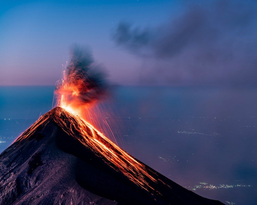
B. Volcanic Activity
Volcanic activity is a potent force driving the formation of new islands in many parts of the world.
Volcanoes, both beneath the ocean’s surface and on land, can spew forth molten rock, ash, and gases, gradually building up layers of volcanic material over time.
As magma rises to the surface and cools, it solidifies into solid rock, eventually forming islands.
In some cases, volcanic eruptions occur underwater, leading to the formation of submarine volcanoes that eventually breach the ocean’s surface, creating new islands.
C. Coastal Processes like Sediment Deposition and Erosion
Coastal processes such as sediment deposition and erosion also contribute to the formation and evolution of new islands.
Sediments carried by rivers, ocean currents, and wind can accumulate along coastlines, gradually building up landmasses known as barrier islands or atolls.
Over time, these sedimentary deposits may consolidate into stable landforms, providing habitat for diverse ecosystems.
Conversely, the relentless forces of erosion, driven by waves, tides, and weathering, can reshape coastlines and carve out new islands from existing landmasses.
The interplay of tectonic forces, volcanic activity, and coastal processes creates a dynamic environment where new islands continually emerge and evolve, shaping the ever-changing tapestry of our planet’s geography.
The Role of Natural Events in Island Formation
A. Volcanic Eruptions
Volcanic eruptions stand as one of the most significant natural events contributing to the formation of new islands.
Beneath the Earth’s surface, molten rock, known as magma, accumulates in chambers below volcanic systems.
When pressure builds up within these chambers, magma may erupt violently through fissures and vents, spewing ash, lava, and gases into the atmosphere.
Over time, repeated eruptions can lead to the accumulation of volcanic material, forming new landmasses above sea level.
Volcanic islands, characterized by rugged terrain and fertile soils, often emerge from the depths of the ocean as a result of such eruptions.
B. Earthquakes
Earthquakes, caused by the sudden release of energy along geological faults, can also influence the formation of new islands.
When tectonic plates shift and collide, immense forces are generated, leading to the fracturing and displacement of Earth’s crust.
In coastal regions, underwater earthquakes may trigger submarine landslides or uplift sections of the seafloor, altering the topography of the ocean bed.
In some cases, seismic activity may result in the emergence of new islands as previously submerged landmasses rise above the water’s surface.
However, earthquakes can also lead to the destruction or submergence of existing islands, highlighting the dual nature of their impact on island formation.
C. Tsunamis
Tsunamis, colossal oceanic waves triggered by underwater disturbances, can play a transformative role in island formation.
Generated by events such as underwater earthquakes, volcanic eruptions, or landslides, tsunamis propagate across vast stretches of ocean, carrying immense volumes of water and sediment.
As these powerful waves crash onto coastlines, they can reshape coastal landscapes, erode shorelines, and deposit sediments inland.
In some cases, the deposition of sediment carried by tsunamis can contribute to the growth of existing islands or the formation of new landmasses along coastlines.
However, tsunamis also pose significant risks to coastal communities and ecosystems, underscoring the complex interplay between natural events and island formation.
Now let’s take a closer look at 8 of the world’s newest islands formed in the last 20 years:
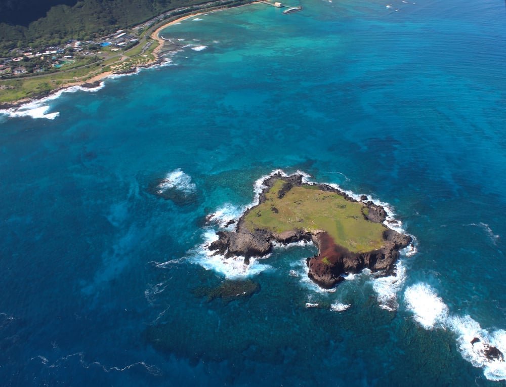
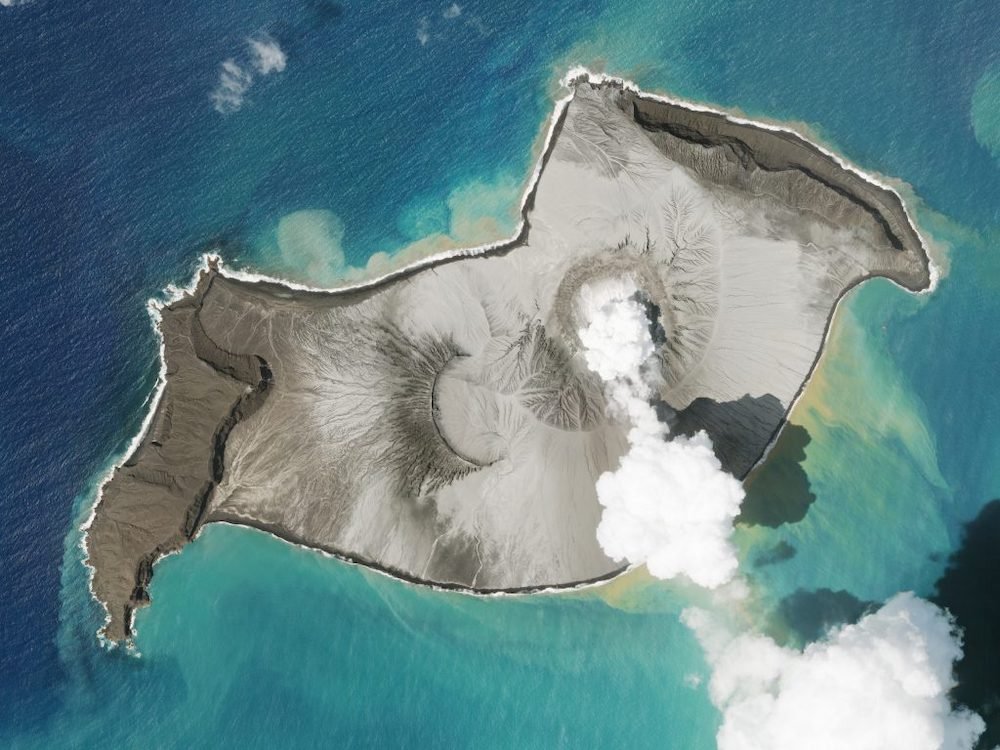
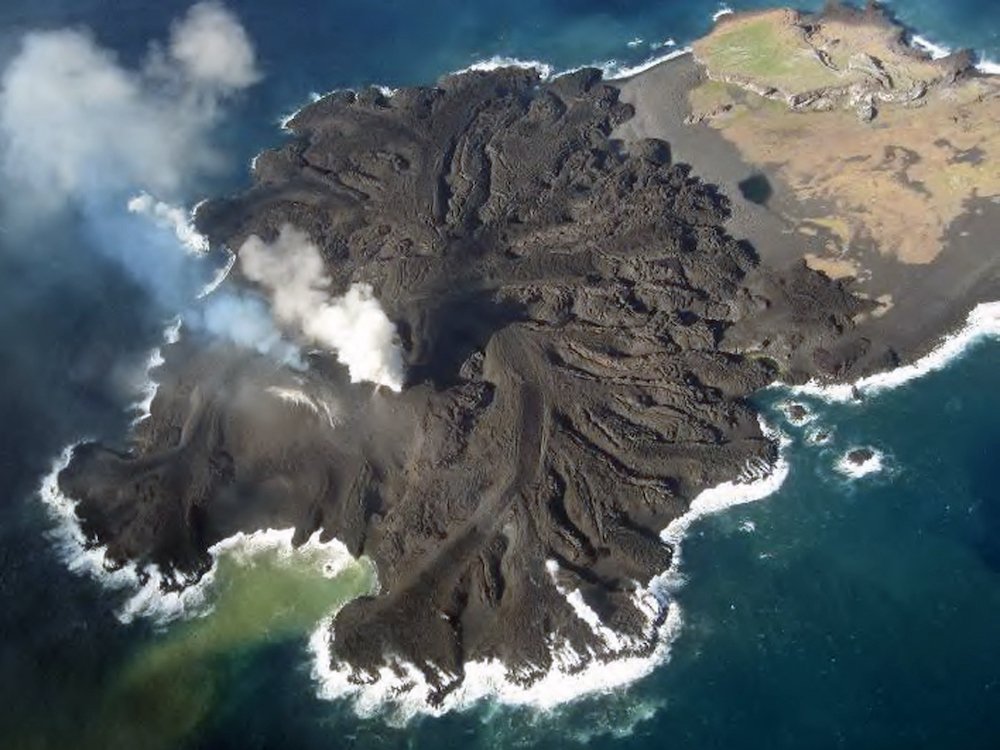
1. Hunga Tonga
Hunga Tonga is located in the South Pacific Ocean, specifically within the Kingdom of Tonga, a Polynesian archipelago in the southern Pacific Ocean.
It lies to the northwest of the Tongatapu Island, the main island of Tonga.
Hunga Tonga emerged as a result of a volcanic eruption that began in late December 2014 and continued into early 2015.
The eruption occurred in the vicinity of the Hunga Ha’apai underwater volcano, leading to the formation of a new island.
The formation of Hunga Tonga was primarily driven by a series of explosive volcanic eruptions originating from the Hunga Ha’apai submarine volcano.
These eruptions ejected vast quantities of volcanic ash, rock fragments, and lava into the air and sea, gradually building up a new landmass above the ocean’s surface.
The eruption was accompanied by dramatic displays of pyroclastic flows and volcanic lightning, marking the violent birth of the new island.
Hunga Tonga is characterized by its rugged terrain, formed by the accumulation of volcanic material ejected during the eruption.
The island’s landscape consists of steep cliffs, volcanic cones, and rocky outcrops, sculpted by the forces of volcanic activity and erosion.
In the aftermath of the eruption, scientists observed the rapid colonization of the island by plant and animal species, highlighting its potential as a natural laboratory for studying ecological processes.
Additionally, the formation of Hunga Tonga attracted international attention due to its status as one of the world’s newest islands, offering valuable insights into the dynamic nature of volcanic phenomena in the South Pacific region.
2. Nishinoshima
Nishinoshima is situated in the Ogasawara Archipelago, also known as the Bonin Islands, in the western Pacific Ocean. It is part of the Tokyo Metropolis in Japan and lies approximately 940 kilometers south of Tokyo.
Nishinoshima experienced a significant volcanic eruption that commenced in November 2013 and continued into the following year, leading to the emergence of a new island.
The eruption resulted in the fusion of Nishinoshima with a nearby islet known as Nishinoshima Kita, forming a larger landmass.
The formation of Nishinoshima was triggered by a series of explosive volcanic eruptions originating from a submarine volcano beneath the ocean’s surface.
Lava flows, ash plumes, and pyroclastic materials erupted from the vent, gradually building up layers of volcanic rock and ash above sea level.
Over time, the accumulation of volcanic material expanded the land area of Nishinoshima, transforming it into a prominent island within the Ogasawara Archipelago.
Nishinoshima is distinguished by its dynamic volcanic landscape, characterized by rugged terrain, volcanic craters, and lava fields.
The island continues to undergo volcanic activity, with periodic eruptions shaping its topography and landforms.
Nishinoshima’s volcanic soil supports the growth of vegetation, attracting seabirds and other wildlife to the island.
The ongoing evolution of Nishinoshima serves as a natural laboratory for scientists studying volcanic processes and ecosystem dynamics, offering insights into the mechanisms driving island formation and ecological succession in volcanic environments.
3. Norderoogsand
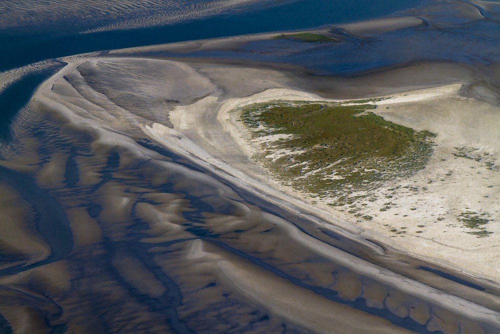
Norderoogsand is situated in the North Sea, off the coast of Germany, within the Wadden Sea National Park. It is part of the East Frisian Islands, a chain of barrier islands along the German coastline.
Norderoogsand has been forming gradually over time due to sediment deposition and coastal processes in the Wadden Sea region.
However, pinpointing a specific date of formation for Norderoogsand is challenging, as the island’s emergence is part of ongoing geomorphological changes within the Wadden Sea ecosystem.
The formation of Norderoogsand is primarily driven by sediment deposition carried by ocean currents and tidal forces in the Wadden Sea.
As sediment accumulates along the shallow seabed, sandbanks and small islands like Norderoogsand emerge, contributing to the dynamic landscape of the East Frisian Islands.
Norderoogsand is characterized by its shifting sand dunes, salt marshes, and tidal flats, which are vital habitats for numerous bird species and marine life.
The island serves as an important breeding ground and stopover site for migratory birds, attracting ornithologists and nature enthusiasts from around the world.
Additionally, Norderoogsand is part of the UNESCO World Heritage Site of the Wadden Sea, recognizing its ecological significance and unique coastal landscape.
4. Tugtuligssup Sarqardlerssuua
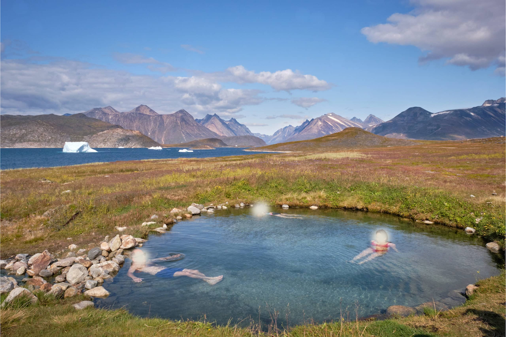
Tugtuligssup Sarqardlerssuua, also known as Uunartoq Qeqertaq, is located off the coast of Greenland in the Arctic Ocean. It is part of the Qaasuitsup municipality in northwestern Greenland.
The exact date of formation for Tugtuligssup Sarqardlerssuua is difficult to pinpoint due to the remote and inaccessible nature of the Arctic region.
However, the island is believed to have formed relatively recently, likely within the last few decades, as a result of glacial retreat and coastal processes in Greenland.
The formation process of Tugtuligssup Sarqardlerssuua is closely tied to the retreat of glaciers and the melting of ice caps in Greenland due to global warming and climate change.
As temperatures rise, glaciers and ice sheets recede, releasing large quantities of meltwater that contribute to the formation of new landmasses along Greenland’s coastline.
Tugtuligssup Sarqardlerssuua likely emerged as a result of sediment deposition and the deposition of glacial moraines left behind by retreating ice sheets.
Tugtuligssup Sarqardlerssuua is characterized by its rugged, glaciated terrain and pristine Arctic environment.
The island is surrounded by towering icebergs and frigid waters, making it a challenging but rewarding destination for adventurous travelers and researchers.
Tugtuligssup Sarqardlerssuua also serves as a critical habitat for Arctic wildlife, including polar bears, seals, and seabirds, highlighting its ecological significance in the remote reaches of the Arctic.
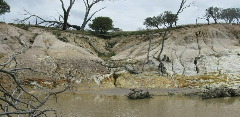
5. Pinto Lake Mystery Island

Pinto Lake Mystery Island is located in Pinto Lake, a freshwater lake situated in California, United States, near the city of Watsonville in Santa Cruz County.
The formation of Pinto Lake Mystery Island is shrouded in mystery, as its origin and date of formation remain uncertain.
The island’s emergence is believed to be relatively recent, likely occurring within the last few decades, although exact details regarding its formation process are elusive.
The formation process of Pinto Lake Mystery Island is subject to speculation and conjecture.
Some theories suggest that the island may have formed as a result of sediment deposition and natural geomorphological processes within Pinto Lake.
Others propose more unconventional explanations, including the possibility of tectonic activity or human intervention.
However, further research and investigation are needed to unravel the enigmatic origins of Pinto Lake Mystery Island.
Pinto Lake Mystery Island is notable for its enigmatic presence within the tranquil waters of Pinto Lake.
The island’s secluded location and mysterious origins have captured the imagination of locals and visitors alike, inspiring curiosity and intrigue.
Despite its small size, Pinto Lake Mystery Island serves as a unique landmark and focal point for exploration and contemplation in the scenic landscape of Santa Cruz County.
6. Bhasan Char
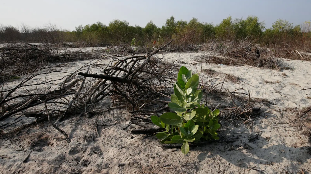
Bhasan Char, also known as Thengar Char, is situated in the Bay of Bengal, off the coast of Bangladesh.
It is located approximately 21 miles (34 kilometers) from the mainland and falls under the administrative jurisdiction of Hatiya Upazila in Noakhali District.
Bhasan Char began to form around the mid-2000s as a result of sediment deposition carried by the Meghna River and other rivers in the Ganges-Brahmaputra-Meghna delta.
The island’s formation accelerated following the construction of embankments and flood control structures in the region, which altered sediment deposition patterns and created new landmasses in the Bay of Bengal.
The formation process of Bhasan Char is primarily driven by sediment deposition and accretion, a natural process whereby sediment accumulates and builds up over time.
As sediment-laden rivers like the Meghna discharge their load into the Bay of Bengal, sediment settles and accumulates on submerged shoals and sandbars, gradually forming new islands like Bhasan Char.
Bhasan Char is characterized by its relatively flat topography and sandy terrain, punctuated by sparse vegetation and mangrove forests.
The island serves as a potential relocation site for Rohingya refugees fleeing persecution in Myanmar, with the Bangladeshi government undertaking initiatives to develop infrastructure and facilities on the island.
Bhasan Char’s unique geopolitical and humanitarian significance has sparked international attention and debate, highlighting the complex challenges associated with climate-induced displacement and resettlement in coastal regions.
7. Sif Island
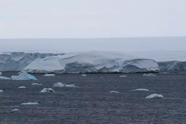
Sif Island is situated in Pine Island Bay, West Antarctica, emerging as a result of the steady retreat of both Pine Island Glacier and Thwaites Glacier.
The island is an ice-covered, thousand-foot slab of granite, discovered by researchers of the Thwaites Glacier Offshore Research (THOR) project in 2020.
The formation of Sif Island is attributed to a process called postglacial rebound, where the retreat of glaciers releases pressure on the land, causing rocky formations like Sif Island to rise.
As Pine Island and Thwaites glaciers recede, rocky bits like Sif Island emerge from beneath the ice.
Unique features of Sif Island include its ice-covered granite composition and its emergence as a result of glacial retreat in the region.
Named after the Norse goddess of the earth, Sif Island provides valuable insights into the dynamic processes shaping Antarctica’s landscape and the impacts of climate change on glacial environments.
8. Lo’ihi Seamount
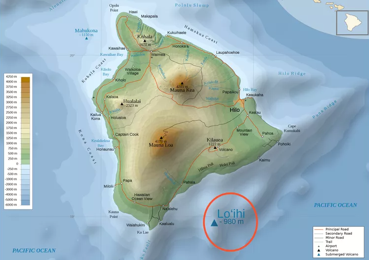
Lo’ihi Seamount is located in the Pacific Ocean, approximately 22 miles (35 kilometers) off the southeastern coast of the Big Island of Hawaii, United States.
The formation of Lo’ihi Seamount began thousands of years ago as a result of volcanic activity along the Hawaiian-Emperor seamount chain.
However, the seamount continues to grow and evolve through ongoing volcanic eruptions and magma intrusions.
The formation process of Lo’ihi Seamount is driven by the movement of the Pacific tectonic plate over a hotspot in the Earth’s mantle beneath the Hawaiian Islands.
As magma rises from the mantle and erupts onto the ocean floor, it accumulates layer upon layer, gradually building up the seamount’s cone-shaped structure.
Lo’ihi Seamount is characterized by its relatively young age compared to the older volcanic islands of the Hawaiian archipelago.
Unique features of Lo’ihi Seamount include its submarine volcanic vents, hydrothermal vents, and diverse ecosystems that thrive in the deep-sea environment.
The seamount provides habitat for a variety of marine organisms, including deep-sea fish, invertebrates, and microbial communities adapted to extreme conditions.
Lo’ihi Seamount is also a site of scientific interest and research, offering insights into the processes of underwater volcanism, oceanic crust formation, and deep-sea ecology.
Conclusion
The formation of new islands stands as a testament to the dynamic and ever-changing nature of our planet’s geology.
From the remote expanses of the Pacific Ocean to the fringes of continental shelves, the emergence of new landmasses offers invaluable insights into Earth’s geological processes and environmental dynamics.
Whether born from volcanic eruptions, sediment deposition, or tectonic activity, these newest islands serve as natural laboratories for scientific inquiry and exploration.
As we look to the future, the study of new island formation holds immense potential for advancing our understanding of Earth’s geological history and the forces shaping our planet.
Continued research and monitoring of these dynamic landforms are essential for unraveling the mysteries of island formation, ecological succession, and climate change impacts.
Furthermore, the conservation and sustainable management of new islands and their surrounding marine environments are paramount to preserving biodiversity and safeguarding fragile ecosystems for future generations.
In the years ahead, interdisciplinary collaboration among scientists, policymakers, and local communities will be crucial for addressing the complex challenges and opportunities associated with new island formation.
By harnessing the power of innovation, technology, and environmental stewardship, we can unlock new frontiers of knowledge and ensure the resilience and vitality of Earth’s newest islands for generations to come.

FAQ’s About the Newest Islands:
What’s the Newest Island on Earth?
The newest island on Earth is often subject to change due to ongoing geological processes such as volcanic eruptions, sediment deposition, and tectonic activity.
As of the latest available information, islands like Hunga Tonga-Hunga Ha’apai in the Kingdom of Tonga and Nishinoshima in Japan are among the relatively recent additions to the world’s island roster.
What Is the New Island in 2023?
As of 2023, specific details about a newly formed island may vary depending on recent geological events. Islands can form due to volcanic eruptions, coastal processes, or tectonic shifts.
To identify the newest island in 2023, it would be essential to refer to the latest geological surveys, satellite imagery, and scientific reports.
Did Japan Just Get a New Island?
Japan has experienced volcanic activity that occasionally leads to the emergence of new islands.
One such example is Nishinoshima, which experienced a significant eruption in 2013, resulting in the formation of a new island.
However, whether Japan “just” got a new island would depend on the timing of recent volcanic activity and geological events.
Did They Discover 7000 New Islands?
The claim of discovering 7000 new islands would need to be verified based on credible sources and scientific data.
Islands can be discovered through various means, including satellite imagery, aerial surveys, and geological expeditions.
While the Earth’s surface continues to be explored, the discovery of thousands of new islands would represent a significant scientific achievement.
What Islands Don’t Exist Anymore?
Islands can disappear due to natural processes such as erosion, sea level rise, and tectonic activity.
Additionally, human activities such as land reclamation, coastal development, and climate change can contribute to the disappearance of islands.
Some examples of islands that no longer exist in their original form include parts of the Maldives, which are threatened by rising sea levels.
Is Bora Bora Sinking?
Bora Bora, like many low-lying islands, faces challenges related to sea level rise and coastal erosion.
While Bora Bora itself is not sinking in the literal sense, the island’s vulnerability to erosion and inundation from rising sea levels is a concern for its long-term sustainability and resilience.
Efforts to mitigate these threats include coastal protection measures and sustainable development practices.
Are Islands Still Forming?
Yes, islands are still forming around the world due to volcanic activity, sediment deposition, and tectonic processes.
Volcanic eruptions, coastal sedimentation, and geological uplift contribute to the emergence of new landmasses in various parts of the world.
Ongoing scientific research and monitoring help us understand the processes behind island formation and their implications for geology, ecology, and human society.


(Island Expert)
Christian is a dynamic serial entrepreneur and a licensed real estate agent with a relentless passion for unlocking the potential of island real estate. Christian's expertise extends beyond entrepreneurship and property transactions. He possesses a profound expertise in crafting captivating content and persuasive copywriting tailored exclusively to the enchanting realm of island real estate.